 Catalogue PIGMA
Ifremer / CERSAT > Satellite Data Processing and Distribution Center of the French Research Institute for Exploitation of the Sea
Type of resources
Available actions
Topics
Keywords
Contact for the resource
Provided by
Formats
Representation types
status
Scale
Resolution
-
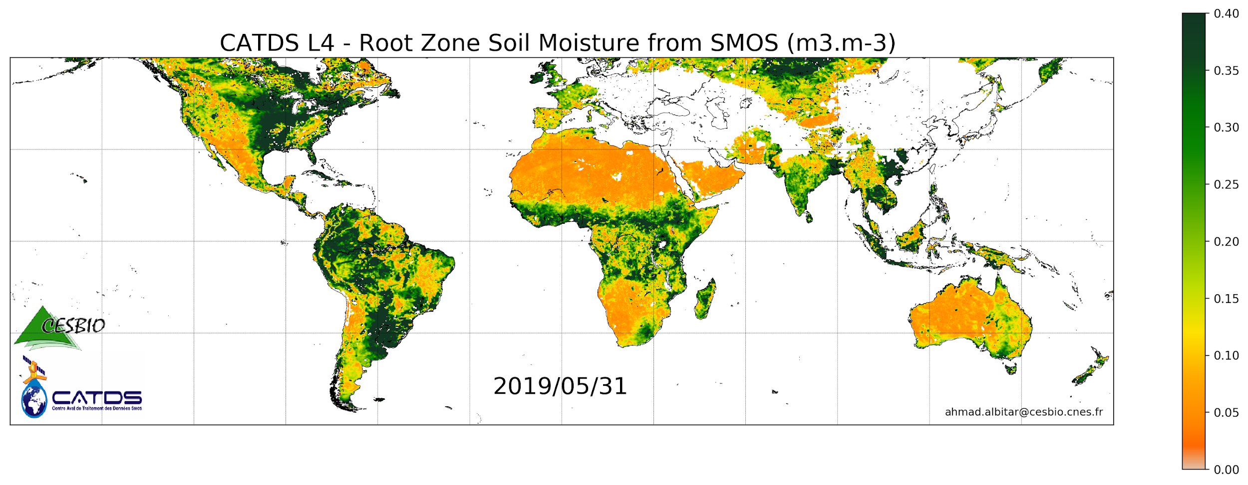
This product is a daily product of root zone soil moisture representative of the 0-1 m depth of the soil. The base products, for all the CATDS-PDC (Centre Aval de Traitement des Données SMOS - Production & Dissemination Center) processing chains, are the SMOS L1B products from ESA (European Space Agency). The L4SM RZSM is the daily product of root zone soil moisture (m3/m3) representative of the 0-1 m depth of the soil. The product contains also a quality index taking into account the presence of Radio Frequency Interference (RFI), low quality of retrieval of the input surface soil moisture, and a high fraction of non-nominal surfaces. Products from reprocessing RE07 are available for the period 01/2010 - 05/2021. Products from operational (OPER) processing are available since 06/2021. Reprocessed products and operational products are derived using the same algorithm and configuration, hence ensuring the temporal continuity.
-
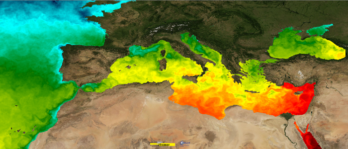
This dataset provide a times series of daily mean fields of Sea Surface Temperature (SST) foundation at ultra-high resolution (UHR) on a 0.02 x 0.02 degree grid (approximately 2 x 2 km) for the Mediterranean Sea, every 24 hours. An Optimal interpolation (OI) technique is used to combine coincident swath measures of SST from different types satellite sensors and to fill gaps where no observations are available or obstructed by clouds. This multi-sensor compositing and interpolation process categorizes this dataset as a Level 4 product. Whereas along swath observation data essentially represent the skin or sub-skin SST, the L4 SST product is defined to represent the SST foundation (SSTfnd). SSTfnd is defined within GHRSST-PP as the temperature at the base of the diurnal thermocline. It is so named because it represents the foundation temperature on which the diurnal thermocline develops during the day. SSTfnd changes only gradually along with the upper layer of the ocean, and by definition it is independent of skin SST fluctuations due to wind- and radiation-dependent diurnal stratification or skin layer response. It is therefore updated at intervals of 24 hrs. SSTfnd corresponds to the temperature of the upper mixed layer which is the part of the ocean represented by the top-most layer of grid cells in most numerical ocean models. It is never observed directly by satellites, but it comes closest to being detected by infrared and microwave radiometers during the night, when the previous day's diurnal stratification can be assumed to have decayed. The processing combines the observations of multiple polar orbiting and geostationary satellites, embedding infrared of microwave radiometers. All these sources are intercalibrated with eachother before merging. The processing is the same as for the Atlantic Near Real Time (NRT) L4 dataset available on Copernicus Marine Service [SST_ATL_SST_L4_NRT_OBSERVATIONS_010_025 dataset] and users can refer to the user manual and quality documents available there for more details. This dataset was developed in the frame of European Space Agency (ESA)'s Medspiration project.
-
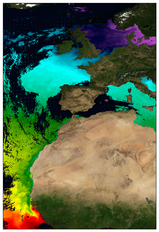
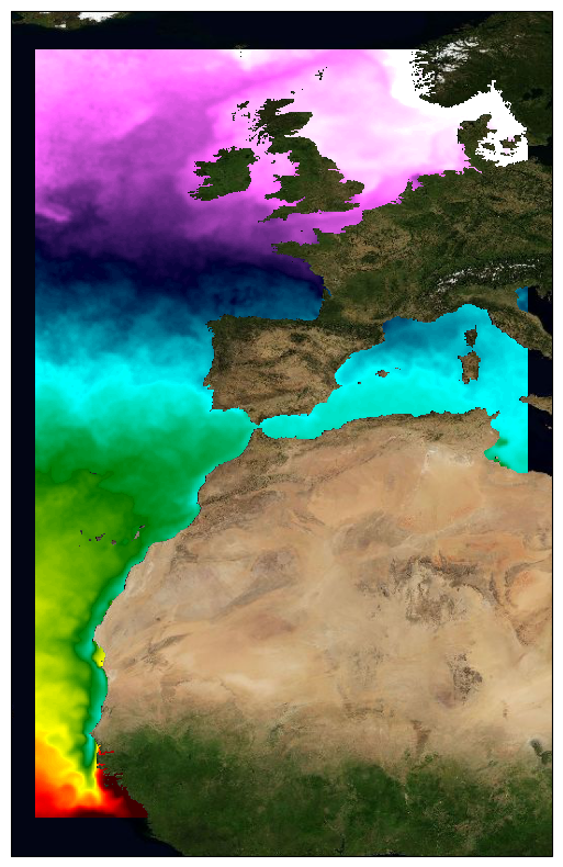
This dataset provide a times series of daily multi-sensor composite fields of Sea Surface Temperature (SST) foundation at ultra high resolution (UHR) on a 0.02 x 0.02 degree grid (approximately 2 x 2 km) for the North-East Atlantic (European North West shelf, Iberia, Bay of Biscay, Irish Sea down to Canary upwelling), every 24 hours. Whereas along swath observation data essentially represent the skin or sub-skin SST, the L3S SST product is defined to represent the SST foundation (SSTfnd). SSTfnd is defined within GHRSST as the temperature at the base of the diurnal thermocline. It is so named because it represents the foundation temperature on which the diurnal thermocline develops during the day. SSTfnd changes only gradually along with the upper layer of the ocean, and by definition it is independent of skin SST fluctuations due to wind- and radiation-dependent diurnal stratification or skin layer response. It is therefore updated at intervals of 24 hrs. SSTfnd corresponds to the temperature of the upper mixed layer which is the part of the ocean represented by the top-most layer of grid cells in most numerical ocean models. It is never observed directly by satellites, but it comes closest to being detected by infrared and microwave radiometers during the night, when the previous day's diurnal stratification can be assumed to have decayed. The processing combines the observations of multiple polar orbiting and geostationary satellites, embedding infrared of microwave radiometers. All these sources are intercalibrated with each other before merging. A ranking procedure is used to select the best sensor observation for each grid point. The processing is described on Copernicus Marine Service [SST_ATL_PHY_L3S_NRT_010_037 dataset] and users can refer to the user manual and quality documents available there for more details. This dataset is generated daily within a 24 delay and is therefore suitable for assimilation into operational models. It is produced in the frame of Copernicus Marine Service and the data available through various tools and protocols with a simple user registration from this service (product identifier: SST_ATL_PHY_L3S_NRT_010_037) at: https://data.marine.copernicus.eu/product/SST_ATL_PHY_L3S_NRT_010_037/
-
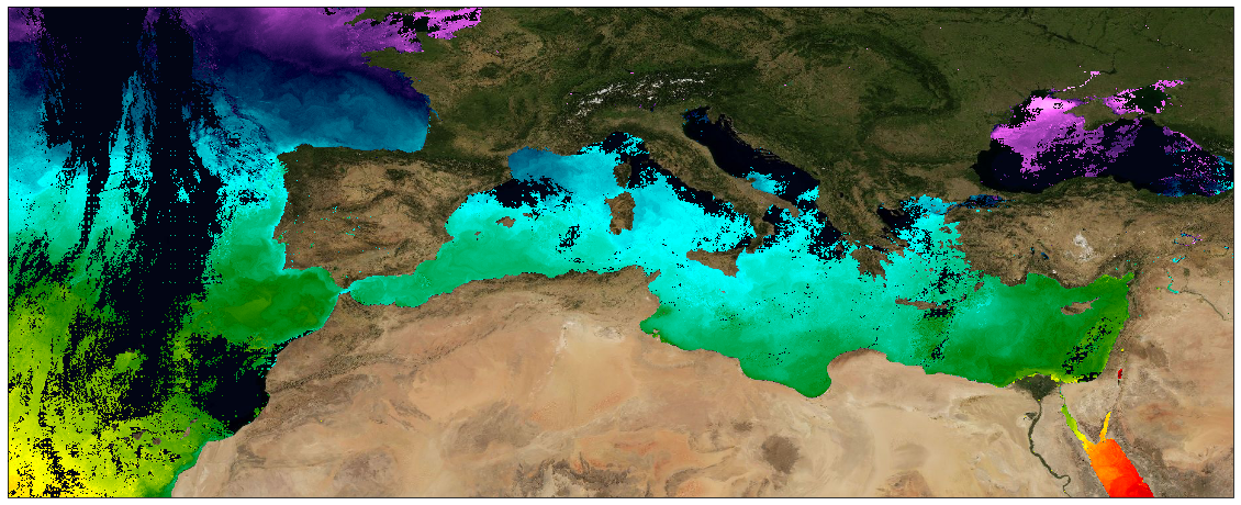
This dataset provide a times series of daily multi-sensor composite fields of Sea Surface Temperature (SST) foundation at ultra high resolution (UHR) on a 0.02 x 0.02 degree grid (approximately 2 x 2 km) over Mediterranean Sea, every 24 hours. Whereas along swath observation data essentially represent the skin or sub-skin SST, the L3S SST product is defined to represent the SST foundation (SSTfnd). SSTfnd is defined within GHRSST as the temperature at the base of the diurnal thermocline. It is so named because it represents the foundation temperature on which the diurnal thermocline develops during the day. SSTfnd changes only gradually along with the upper layer of the ocean, and by definition it is independent of skin SST fluctuations due to wind- and radiation-dependent diurnal stratification or skin layer response. It is therefore updated at intervals of 24 hrs. SSTfnd corresponds to the temperature of the upper mixed layer which is the part of the ocean represented by the top-most layer of grid cells in most numerical ocean models. It is never observed directly by satellites, but it comes closest to being detected by infrared and microwave radiometers during the night, when the previous day's diurnal stratification can be assumed to have decayed. The processing combines the observations of multiple polar orbiting and geostationary satellites, embedding infrared of microwave radiometers. All these sources are intercalibrated with each other before merging. A ranking procedure is used to select the best sensor observation for each grid point. The processing is the same (minus the optimal interpolation step) as for the Atlantic Near Real Time (NRT) L3S dataset available on Copernicus Marine Service [SST_ATL_PHY_L3S_NRT_010_037 dataset] and users can refer to the user manual and quality information documents available there for more details. This dataset is generated daily within a 24 delay and is therefore suitable for assimilation into operational models.
-
This dataset provide a times series of daily multi-sensor composite fields of Sea Surface Temperature (SST) foundation at ultra-high resolution (HR) on a 0.02 x 0.02 degree grid (approximately 2 x 2 km) for the North East Atlantic, every 24 hours. An Optimal interpolation (OI) technique is used to combine coincident swath measures of SST from different types satellite sensors and to fill gaps where no observations are available or obstructed by clouds. This multi-sensor compositing and interpolation process categorizes this dataset as a Level 4 product. Each daily mean field is available the next day before 12:00. Whereas along swath observation data essentially represent the skin or sub-skin SST, the L3S SST product is defined to represent the SST foundation (SSTfnd). SSTfnd is defined within GHRSST as the temperature at the base of the diurnal thermocline. It is so named because it represents the foundation temperature on which the diurnal thermocline develops during the day. SSTfnd changes only gradually along with the upper layer of the ocean, and by definition it is independent of skin SST fluctuations due to wind- and radiation-dependent diurnal stratification or skin layer response. It is therefore updated at intervals of 24 hrs. SSTfnd corresponds to the temperature of the upper mixed layer which is the part of the ocean represented by the top-most layer of grid cells in most numerical ocean models. It is never observed directly by satellites, but it comes closest to being detected by infrared and microwave radiometers during the night, when the previous day's diurnal stratification can be assumed to have decayed. The processing combines the observations of multiple polar orbiting and geostationary satellites, embedding infrared of microwave radiometers. All these sources are intercalibrated with eachother before merging. This dataset is generated daily within a 24 delay and is therefore suitable for assimilation into operational models. It is produced in the frame of Copernicus Marine Service and the data available through various tools and protocols with a simple user registration from this service (product identifier: SST_ATL_SST_L4_NRT_OBSERVATIONS_010_025) at: https://data.marine.copernicus.eu/product/SST_ATL_SST_L4_NRT_OBSERVATIONS_010_025/
-
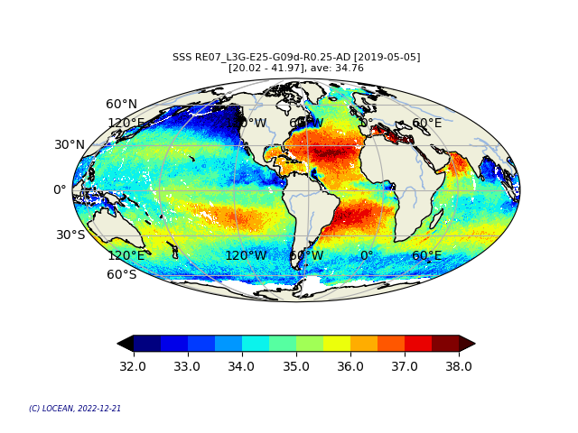
This product contains daily salinity fields from a 9 days temporal gaussian average, corrected from land-sea contamination and latitudinal bias, based on L2Q products, mixing ascending and descending orbits. The base products, for all the CATDS-PDC (Centre Aval de Traitement des Données SMOS - Production & Dissemination Center) processing chains, are the SMOS L1B products from ESA (European Space Agency). From these, brightness temperatures at various incidence angles are reconstructed. The Sea Surface Salinity (SSS) are retrieved from multi-angular brightness temperatures through a maximum likehood Bayesian approach in which measured Tb and Tb simulated using a forward direct model are compared (see Zine et al. 2008 for a general description of the retrieval method, and pro_con table for a summary of the similarities/differences with respect to ESA level 2 ocean salinity processing). Products from reprocessing RE07 are available for the period 02/2010 - 05/2021. Products from operational (OPER) processing are available since 06/2021. Reprocessed products and operational products are derived using the same algorithm and configuration, hence ensuring the temporal continuity.
-

This dataset provide a times series of daily mean fields of Sea Surface Temperature (SST) foundation at high resolution (UHR) on a 0.10 x 0.10 degree grid (approximately 10 x 10 km) for the Global Ocean, every 24 hours. An Optimal interpolation (OI) technique is used to combine coincident swath measures of SST from different types satellite sensors and to fill gaps where no observations are available or obstructed by clouds. This multi-sensor compositing and interpolation process categorizes this dataset as a Level 4 product. Each daily mean field is available the next day before 12:00. Whereas along swath observation data essentially represent the skin or sub-skin SST, the L4 SST product is defined to represent the SST foundation (SSTfnd). SSTfnd is defined within GHRSST-PP as the temperature at the base of the diurnal thermocline. It is so named because it represents the foundation temperature on which the diurnal thermocline develops during the day. SSTfnd changes only gradually along with the upper layer of the ocean, and by definition it is independent of skin SST fluctuations due to wind- and radiation-dependent diurnal stratification or skin layer response. It is therefore updated at intervals of 24 hrs. SSTfnd corresponds to the temperature of the upper mixed layer which is the part of the ocean represented by the top-most layer of grid cells in most numerical ocean models. It is never observed directly by satellites, but it comes closest to being detected by infrared and microwave radiometers during the night, when the previous day's diurnal stratification can be assumed to have decayed. The processing combines the observations of multiple polar orbiting and geostationary satellites, embedding infrared of microwave radiometers. All these sources are intercalibrated with eachother before merging. This dataset is generated daily within a 24 delay and is therefore suitable for assimilation into operational models. It is produced in the frame of Copernicus Marine Service and the data available through various tools and protocols with a simple user registration from this service (product identifier: SST_GLO_PHY_L4_NRT_010_043) at: https://data.marine.copernicus.eu/product/SST_GLO_PHY_L4_NRT_010_043
-

This dataset provide a times series of daily multi-sensor composite fields of Sea Surface Temperature (SST) foundation at high resolution (HR) on a 0.10 x 0.10 degree grid (approximately 10 x 10 km) for the Global Ocean, every 24 hours. Whereas along swath observation data essentially represent the skin or sub-skin SST, the L3S SST product is defined to represent the SST foundation (SSTfnd). SSTfnd is defined within GHRSST as the temperature at the base of the diurnal thermocline. It is so named because it represents the foundation temperature on which the diurnal thermocline develops during the day. SSTfnd changes only gradually along with the upper layer of the ocean, and by definition it is independent of skin SST fluctuations due to wind- and radiation-dependent diurnal stratification or skin layer response. It is therefore updated at intervals of 24 hrs. SSTfnd corresponds to the temperature of the upper mixed layer which is the part of the ocean represented by the top-most layer of grid cells in most numerical ocean models. It is never observed directly by satellites, but it comes closest to being detected by infrared and microwave radiometers during the night, when the previous day's diurnal stratification can be assumed to have decayed. The processing combines the observations of multiple polar orbiting and geostationary satellites, embedding infrared of microwave radiometers. All these sources are intercalibrated with each other before merging. A ranking procedure is used to select the best sensor observation for each grid point. This dataset is generated daily within a 24 delay and is therefore suitable for assimilation into operational models. It is produced in the frame of Copernicus Marine Service and the data available through various tools and protocols with a simple user registration from this service (product identifier: SST_GLO_SST_L3S_NRT_OBSERVATIONS_010_010) at: https://data.marine.copernicus.eu/product/SST_GLO_SST_L3S_NRT_OBSERVATIONS_010_010